Article Index
(Frank Leyden and six of his friends spent two weeks at the Chalet Charlottes Pass in July 1947. Frank's account of how they travelled to and from the Chalet is reproduced here, along with his account of three successive days of perfect ski touring weather when they skied the Main Range runs of Little Austria, Mt. Townsend, Sentinel Peak and Mt. Twynam.) |
Friday July 11.Departed Cooma 8.45am and arrived Hotel (now Sponars Lakeside Inn) at 11.30am. Departed Hotel about 12 noon and arrived Smiggins at 12.30pm & had lunch. Departed Smiggins on skis 1.30pm and arrived Perisher Gap at 2.30pm. Arrived Chalet at 3.30pm. Went from Hotel to Smiggins in Hotel special austerity bus with chains. Luggage went in jeep type truck. The ranges looked well as we were going down the hill into Jindabyne (which in 1947 was a tiny settlement mostly on the east bank of the Snowy River). The snow was covering the tops well and sweeping down through the trees deep down the ridges. The weather in Cooma and right through to half-way up the mountain west of Jindabyne, was bright, clear & sunny with light west wind. The tops were covered with whitish filmy cloud & underneath it was darker, more turbulent cloud. Snowing lightly and slightly windy at Hotel. Snow-line was well below Rennix Gap and Wilsons Valley. Snow thin on ground & not too good on the Slam Run but a fair covering on the Kerry Course & up towards the Plains of Heaven, but wet and slow. Road to Smiggins wet and some deep drifts. The transport system best yet. Met tractor just below Smiggins & dumped luggage. There was time to get essentials like gloves from packs, but it was cold, windy and snowing. We went on to Smiggins & left packs for the tractor to bring. Joe at Smiggins gave us a good feed. Said he had arranged with Mr Peterson for us to stay in a hut nearby with some bunks & fireplace in it for five shillings a week, or thereabouts, and to have meals for two shillings and sixpence each at Smiggins Café with Joe. Len & Bill thought they would put in a week at Smiggins at the end of this trip. Anyway, one would not be stuck for somewhere to stay. We skied from Smiggins right through to the Chalet without needing to fit skins to our skis. The snow was wind-packed, firm & running beautifully. Snowing lightly & blowing, with practically complete overcast. But the cloud was not thick, nor the wind too bad and the going was quite easy. Had a yarn with Frank Fyfe at Betts Camp & Manfred (who was booked in for two weeks at Betts) decided to try to squeeze in with us at the Chalet, making the party 8 persons altogether. Arriving Chalet we were all booked into a big room (Room 9) together. We went up Stilwell for a run. The snow was sticky & not running well – too warm & misty. Then climbed half-way up Charlottes Pass, where the packed snow was slightly better to ski on. Meals at Chalet were excellent, well-balanced & plenty – a big improvement on the previous year. The room & facilities were very comfortable & everyone was happy. Arranged to book sleeping berths for our return rail trip from the Chalet Office. We were advised that parties travelling between Hotel and Chalet are expected to check in at Betts Camp and Smiggins Holes. |
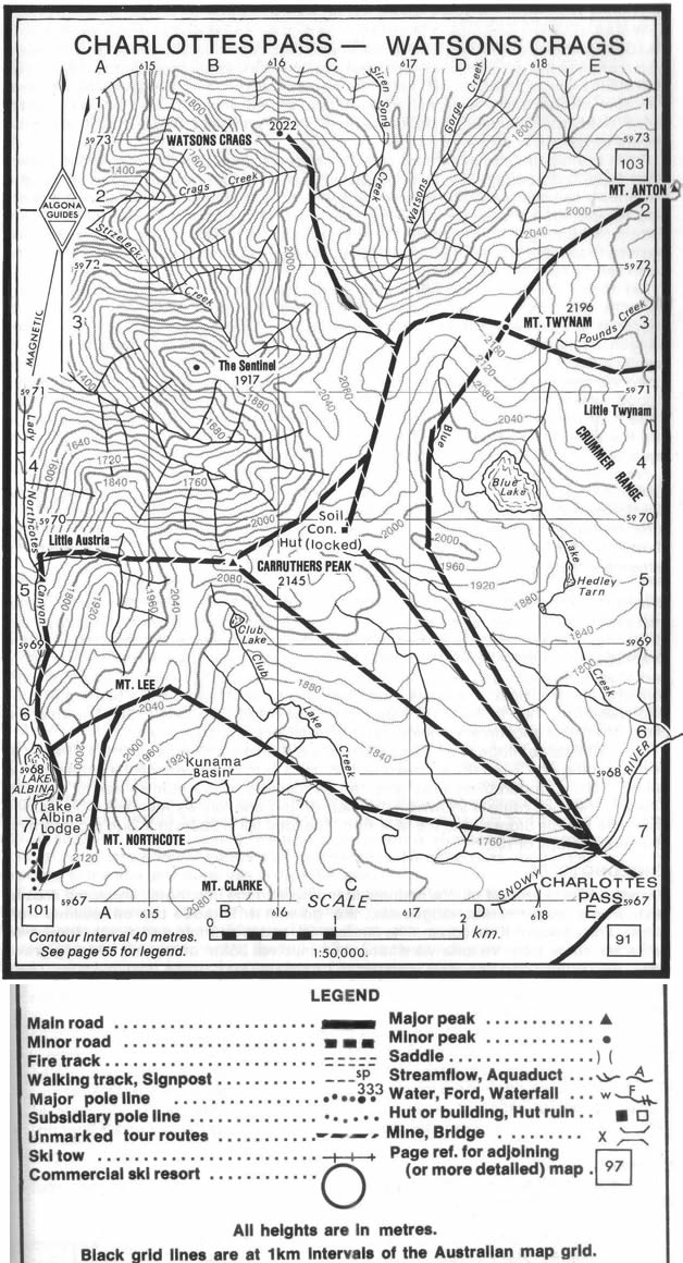
Friday July 18. ("Little Austria Day").Alarm went off at 6.45am as usual and, looking out the window, we saw for the first time this visit, perfectly clear sky, no wind and very cold (- 8°C). Richard sprang into activity; early breakfast was able to be quickly arranged, as some of the guests were going home. Left Chalet in a perfect clear morning at 8.40am. Arrived Formans site (on the Snowy River) at 9.05am and arrived on Carruthers Peak at 10.00am in perfect clear & bright weather. Climbing up to Carruthers we experienced a perfect clear bright morning, with snow very good and wind ribbed. Wind blowing cold from south on top of Carruthers, noticeably dissipating strands of mist in Geehi Valley. Low cloud over Cooma way, also straggly, low cloud over Victoria. Took a few photos on top of Carruthers and then ran across to a valley behind Mt. Lee and waited for the others who were behind. (Please see map "Charlottes Pass – Watsons Crags".) Len Scotland and I ran down one side of the gully & the rest approached down from the Carruthers side and we met at the bottom. Fairly continuously steep, smooth and even beautiful snow for a few hundred feet ending in a narrow gully. We then swung north for a few hundred yards and arrived at the top of the "funnel". The scenery was magnificent and real Alpine (Please see Photo Nos 10 & 11.) We were closed in by steep walls of snow with iced rocks extending for hundreds of feet above the way we were going (being the only negotiable route without practically mountaineering). The snow was perfect running; also perfect weather. The "Funnel" extended for, perhaps, the best part of 1,000 feet. Continuous turns wall to wall were necessary all the way down. Checking was easy in the good snow. Took some photos of trees with ice etc. We ran out into Northcote Canyon below Townsend Spur and went down the canyon a bit & had lunch overlooking Geehi, Grey Mare Pinnacle & The Dargals. Left at about 1.00pm to climb out the same route as we had come. (Photo No. 11) Aneroid barometer read 5225 ft altitude. The waterfall at the bottom was the most difficult feature to climb around. Further up was a small frozen waterfall of columns of green glazed ice thick as a man. The climb out gave beautiful views and light mist wafted up slowly. It was strenuous climbing and took 1.5 hours to climb up to the saddle between Lee & Carruthers. Len and I went up onto Carruthers again. The others ran off towards Lee & found a good slope. On top of Carruthers the earlier wind had dropped and the air was still & calm with magnificent views. Took photos & then ran with Len down to Formans Crossing on the Snowy River. We saw the others ski off Lee in clouds of snow – they appeared to have a good run. We did well high up; the sun had softened the ice on the tops. Crossed the Snowy River and reached Charlottes Pass at 4.00pm. From here we could see mist creeping over Lee but more mist obscured Mt. Tate and Gills Knobs. Kosci was clear. Skied to Chalet thru' the flags down the Pulpit Hill Ski Lift run. |
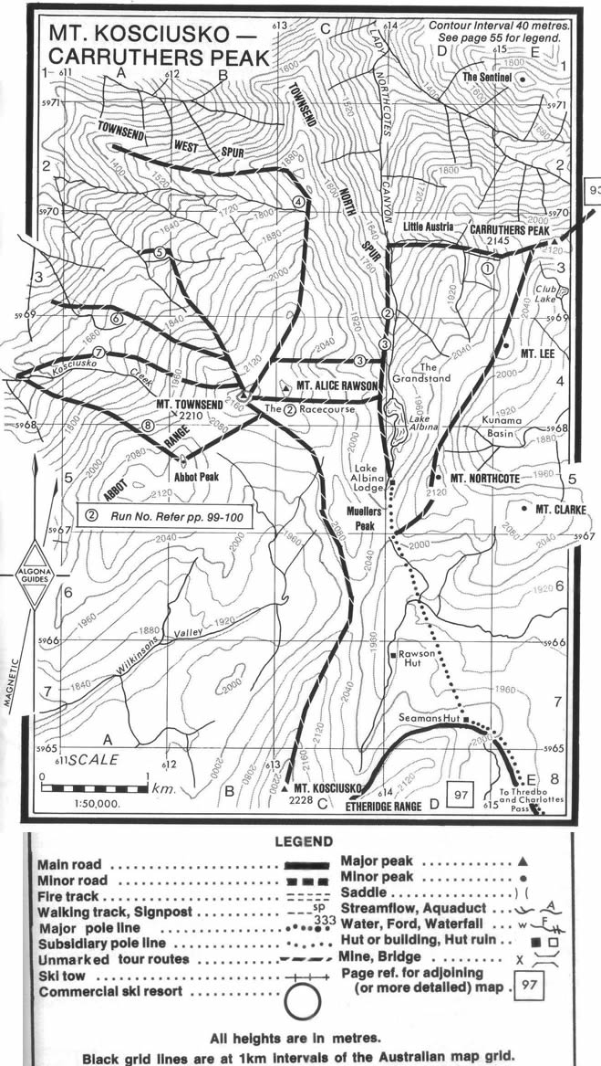
Saturday July 19 ("Townsend Day").Had early breakfast. Fine, bright, clear morning but with light wind from SW causing a weaving sinuous movement flowing over the surface of the snow. Departed Chalet 8.45am. All tops clear. Ran down to Foremans site and went tight up Club Lake Creek to underneath Mt. Lee. Went south and then climbed the saddle between Northcote & Lee. Icy conditions made climbing very difficult. Len Scotland picked a route and got nearly to the top when he slipped and slithered as a snowy mass right down to the bottom of the slope about 50 ft (15m). Eventually, Richard made a track and we got up onto the crest with much trepidation. At every step the snow creaked and groaned. Very slow small steps were necessary, hanging on to the top stock by its base. At the top we took off the skins and ran south along the top for a few hundred yards to the top of a wide gully leading down into Lake Albina. (Please see map Mt. Kosciusko – Carruthers Peak). Geehi and all Victoria was under a sea of low white cloud extending to the horizon, but the tops were all well above the cloud everywhere & so was the country towards Cooma. A light constant wind from SW by S continued all day and was only disturbing in exposed places, but quite fierce on Townsend Trig. The run down off the Northcote – Lee saddle down to Lake Albina was steep but quite nice with the good snow and was easily negotiated. We paused in the shelter of Albina (11.30am), put on skins and then climbed up a gully leading up to Townsend. It was an easy steady climb right to the top. We then went along the wind-swept flat to the base of the final pyramid. This was a bit steep to side-step but over a few bumps and ice flutings, we came to the Trig encased in a mass of eagle's feathers ice formations and the wind was cold and searching. The sea of white cloud extended to all horizons; to the west high reddish cloud was above the main bank. Some holes in the cloud gave glimpses of the timbered ridges below the snow. Pinnibar and the Victorian Alps stood alone, well in the clear; also the Dargals, Jagungal and all the tops in between, also Round Mountain etc. The view was magnificent and the sky above clear & the sun brilliant. Took photos all round; also of the ice flutings on a rock and ice cave. Then ran down from the summit on to the flat & then down the gully to Albina, where we had lunch. The run down was easy and very nice with good snow. There were small crevasses in the snow at the sides of Lake Albina about 6 inches (150mm) wide and going down to green depths extending far across the surface. Went across after lunch to the North end of the lake, to look down into Little Austria, which was in the mist. The climbed onto The Grandstand, views magnificent, then onto the summit of Mt. Lee. The swirling mists were rising up gradually from Little Austria. Ran off Lee to the North for about ¼ mile (400m) then traversed downward to the top of a big rock slope, very steep and hard to hang on; the others soon flew down, but Len and I had to hang on by traversing across the very steep slope. Eventually it became flatter & we soon ran down into Club Lake Valley & thence Snowy River, Charlottes Pass & Chalet at 4pm. On Charlottes we saw mist on Kosci and swirling over Mt Lee, moving fast from the south. In the morning a slight fall in the barometer was observed; also only -5 degrees C. |
Sunday July 20. "Sentinel Peak & Twynam Day".A beautiful morning without any wind, but the sunrise was red and high cloud fingers radiated from the NE horizon. Left Chalet at 8.45am. To Formans (Crossing of the Snowy River) thence up half-way to Carruthers then down into a valley above a cornice and up onto "the tops" north of Carruthers. Ran down into a little valley west of the Blue Lake, to the beginning of the ridge that leads down to Sentinel Peak. Went out along a knife-edge of snow for a few hundred yards before the ridge descended steeply to Sentinel Peak. The views were marvellous (please see Photo Nos. 4 & 5 of the AAC First Heritage Installment) but a SE wind was blowing furiously, especially on this narrow ridge. Took photos & then climbed north on to Twynam West Spur and part of the way out above Watsons Crags. Views excellent (Photo No.13). Had a look at the slopes off Twynam West Spur and Richard Raubitschek said they were not so steep and could easily be run in good snow. Then climbed Mt. Twynam & had lunch just under the Trig Station (Photo No. 12). After lunch ran down to Blister Gap (between Twynam & Little Twynam) and then climbed around onto the North side of Little Twynam and ran down towards the Snowy River. Had to climb a bit to continue the run. Came down to junction of Snowy with Spencer's Creek. Took some photos & rested there. Went up Spencers Creek and arrived at Chalet about 4.30pm. |