Article Index
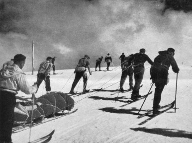
This seventh installment of the AAC's ski heritage photos takes the reader back about fifty years to the TWENTY year period from the late 1930's through to the mid 1950's, during which unprecedented expansion of skiing facilities occurred in Victoria. Photo No.1 shows the usual method of reaching Mt. Hotham in the 1940's. Horses conveyed skiers from Harrietville, up the Bon Accord Spur to the snow line, where skis were put on and used for the remainder of the journey to the Hotham Heights Chalet. Rucksacks were conveyed over the snow by horse-drawn sled. Many changes have occurred since then, including the establishment of ski tows and we tell you about Australia's first two ski tows (Mt. Buffalo had the first).
This seventh installment also looks at the reasons for the lack of development of Mt Bogong (Victoria's highest) – whilst other Victorian resorts expanded, with the construction of ski tows and many new buildings on the snow, each containing from ten to about sixty beds. In March 1951, Malcolm McColl was able to write in the Ski Year Book (SYB), that 22 club lodges would be operating at Mt. Buller that year. He reported that several club and commercial lodges had also been built at Hotham (Drift Chalet, University, Alpine) and Falls Creek (Albury, Bogong, Skyline, Commercial). Club lodges were also built at Mt. BawBaw, Mt. Saint Bernard and Mt. Wills. The long-established Victorian ski field at Donna Buang suffered several winters with minimal snow cover after which its skiing facilities were progressively removed.
Ski accommodation on Mt. Buller in 1940 was one commercial lodge (the Buller Chalet operated by Helmet Kofler shown in Photo No.2) and the Ski Club of Victoria (SCV) hut higher on the mountain at Cow Camp. The SCV hut held 12 to 14 persons overnight in rather cramped conditions, since the hut's floor only measured 6 metres by 3.6 metres. Vehicle access was possible along a bush track as far as the Chalet, facilitating weekend skiing trips from the nearby towns and also from Melbourne. Unfortunately the Chalet burnt down in 1942 and was not rebuilt. It had occupied a reasonably sheltered site near the "Chalet Corner" on the present road from Mirimbah to Mt. Buller Village.
Following the loss of the Chalet and the suspension of many recreational activities for the duration of the Pacific War, thoughts turned to possible developments in the post-war period. The SCV planned to build a larger lodge on Buller in memory of SCV member Ivor Whittaker, who died in a plane crash in the Middle East in September 1941, whilst on active service in the Australian Army. The Club decided to locate this new lodge adjacent to the site of the proposed Mt. Buller ski village at Cow Camp.
Construction of the Ivor Whittaker Memorial Lodge commenced in 1945 and by 1948 it was able to accommodate about 40 skiers (non-members as well as members) each night (Photo No.3). The project was completed prior to the start of the 1950 ski season and included the construction of satellite cabins, whose occupants could eat their meals at the main Ivor Whittaker Lodge.
Sixteen ski clubs had applied by March 1949 to the Forests Commission (which then controlled Mt. Buller) for building sites in the Cow Camp area. The Commission had announced on 1st June 1948 the establishment of a Committee of Management to develop the Cow Camp site as a residential area. Its duties would include setting appropriate building standards and ensuring sanitation, water supply and fire refuges existed and were maintained so as to safely cater for visitors.
Winter access to Mt. Buller from Melbourne up to the mid-1950's, usually involved taking a train or bus to Mansfield, where skiers boarded an old, rattly bus for the rough ride over a narrow, pot-holed road to the foot of the mountain. A four-wheel drive "blitz" ex-army truck then took the skiers to the point where the track was blocked by deep snow (there were no snow-ploughs at Buller then!). The "blitz" could usually get to within 2km of the village. Skiers walked the remaining distance carrying rucksacks and skis.
The Chamois, Postal Institute, CSIRO, YHA, and the Junior Ski Club were fully operational for the 1950 ski season. For the 1951 season they were joined by the Omega, Walking Club, Ullr, Harding, Moose, Women's, Monsanto, University, Yurredla, Dandenong, Morgan, Pattern, Buller and Grey Rocks Club lodges. This brought the total accommodation on Buller to a figure far in excess of that of any other Australian snowfield in 1951.
The first entirely commercial lodge to be built, was Kooroora Chalet (Photo No.4), which opened in 1953. The first ski tow was a rope tow on the Bourke Street Ski Run that operated for the first time in the 1950 ski season. Rope tows were also operating on Bull Run and Little Baldy by 1954. Buller had more than thirty club lodges in operation in the 1954 ski season. Skiers no longer had to carry all their food up the mountain when they arrived via the "blitz" truck. Kooroora Chalet provided fresh bread baked on the mountain, whilst the Ivor Whittaker Lodge, which had a large freezing chamber capable of holding 500 carcases, provided the fresh meat for the mountain.
The only skier accommodation on Mt. Hotham in the 1930's was the Hotham Heights Chalet (Photo No.6). The January 1939 bushfires destroyed it, along with the nearby Mount Saint Bernard Hospice. In a Herculean building effort, a new Hotham chalet was opened in four months by the Victorian Railways (Photo No.7). In the 1939 ski season, it could only accommodate 27 visitors, but it was progressively extended until it could sleep about 80 persons.'
Winter access remained a problem in the 1940's and 1950's (the years prior to the arrival of large snow ploughs in North-Eastern Victoria). From the Harrietville side, the most direct winter access to Hotham involved riding horses up the Bon Accord Spur to the snow line (Photo No. 8), where the skiers donned their skis (Photo No. 1), to which they had attached climbing skins, or similar, whilst they climbed up to the summit of Mt. Hotham. They then skied down to the Chalet about 1km to the east of the summit. Baggage was hauled from the snow line to the Hotham Heights Chalet by horse sled (Photo No. 9). Road access on the Omeo side of Mt. Hotham was usually only available as far as Cobungra Station, from where it was necessary to walk/ski about 20 km to Dinner Plain (which had emergency accommodation in a cattleman's hut, if it was needed) and then a further 9 km to Hotham Heights. Photo
In 1947 the Country Roads Board (CRB) commenced using a Matador truck, with snow-plough blade mounted on its front, to clear as much of the Hotham Road from Harrietville as possible. In the heavy snow year of 1947, it only ever reached a point about 6.5km below Mount St. Bernard, itself a 10km walk from Hotham Heights. Hence the horses on the Bon Accord Spur remained the main means of Winter access. But by 1950, the plough was able to reach the CRB camp at Mount St. Bernard for the entire winter, and the horse access system was terminated. This left the skiers with the 10km long, arduous and risky trek from St. Bernard to Hotham Heights, nearly all of it above the tree-line. This route was exposed to the full-force of the bad weather, particularly the storms coming from the north-west. It did become so icy on occasions, particularly on the very steep and exposed slopes of Mt. Blowhard, that skis could not grip the slope in the icy conditions and skiers had to kick steps into the ice, whilst carrying both their packs and their skis.
Lindsay Salmon's "Drift Chalet" opened in 1952 as the second commercial chalet on Mt. Hotham, with accommodation for up to 45 guests. An insight into its operation was given in a 2009 interview by Ms Joan Graves, who worked there as a cook's assistant in the 1955 ski season. Joan had walked in from the Harrietville side, on a sunny day in July 1955, to commence work. Lindsay Salmon's staff members were accommodated in the poorly heated, very lowest levels of the chalet. Joan said she was lucky to get out of the Chalet to go skiing for a couple of week-day afternoons each week. With a Saturday changeover, she was busy all weekend washing linen, as well as serving afternoon tea on Saturday afternoon to the new arrivals.
Many guests would drive to Omeo on the Friday night and stay overnight in one of the hotels there. They would depart early on Saturday morning and drive to Cobungra, so that the snow was still firm and easy to walk on, when they started their 29km walk/ski to Hotham Heights.
There was no Ski Patrol and no Ski Rescue service. In 1955 a Drift Chalet guest suffered a spiral fracture to one of his legs whilst skiing on the Blue Ribbon Ski Run. He had to lie in the snow whilst his ski companions skied to the Hotham Heights Hotel for an Akja Rescue Sled. The leg was splinted with clothing (no bandages available) and he was taken to the Drift Chalet.
Blizzard conditions set in overnight and the injured skier spent an uncomfortable night on a bed in the Drift Chalet. A holidaying doctor, who was staying as a guest at the hotel, was located the next day and he came to the Drift Chalet to set the broken leg. A sled was located that was suitable for six of his fellow skiers to drag the injured man the 10km to Dinner Plain. There were three skiers at the front and three at the back to steady the sled on the downhill descents. A photo of a 1950 evacuation of an injured skier is presented as Photo No.10. Five skiers can be seen, wearing belts linked to the sled by ropes.
A 4WD tray truck, driven by local identity Fred Ward, met the party at Dinner Plain and the sled plus patient was strapped securely onto the tray of the truck for the 20km descent over snow down to Cobungra, where the ambulance from Omeo awaited them. It had taken a total of 12 hours to evacuate the injured skier from Hotham to the Omeo Hospital.
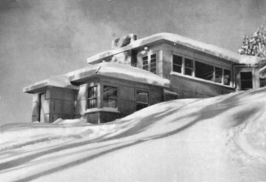
The first club to build at Hotham was the Alpine Club (Melbourne) whose 14 bed lodge was built in the first few months of 1946. The walls of the ground floor are of attractive local stone and the upper storey is of timber sheeted with fibro-cement, whilst the roof slopes at a very shallow angle so as to retain the snow and so help retain the warmth within the building during the ski season. A water spring was located on the slopes of Mt. Higginbotham behind the lodge, that provided water to the lodge with a head of 8m for the 20 years prior to the installation of a reticulated village water supply. The lodge of the University Ski Club (Photo No.11) was built to a similar design nearby in 1948. Like Alpine's lodge, its design minimised the length of walls that were exposed to the weather, whilst its gently sloping roof retained snow for warmth.
In 1947, the Edelweiss Club bought an existing prefabricated building in Gippsland, dismantled it, loaded it onto two trailers and took it to their block in the Davenport Area of Hotham, via the very steep Cobungra Hill. The building was completed and made reasonably weather-proof over the June King's Birthday Holiday weekend and it operated reasonably well at first. Unfortunately, the 1947 Ski Season was a particularly heavy one and by September there was four metres of snow on the roof causing some of the cement roofing sheets to crack and leak. Then, in a November storm, half of the roof was blown away ! After several work-parties had repaired the damage and cleaned up the sodden lodge interior, the lodge worked well!
The members of Wangaratta Ski Club were concerned at the time-consuming and difficult Winter access to Mt. Hotham for skiers travelling from Wangaratta, that often involved delays of a day, or more, due to bad weather. In 1947 the Club established its own lodge at Mount Saint Bernard (Photo No.12), at an altitude of 1500m, which was expected to be the limit of snow-clearing on the relatively sheltered access road from Harrietville in winter. The club has since installed its own rope tow and, for the 1954 ski season, installed a safe snow pole line from Saint Bernard to Hotham. There is also the possibility of ski touring from Mt. St. Bernard along the Dargo High Plains Road to the south and also along the Twins Road to the south-west of the club hut. Another ski touring option is to ski east down into the Dargo River from the top snow pole at the north end of Mt. Blowhard, where the snow can last well into Spring.
Construction of the Kiewa Hydro-Electric Scheme by the State Electricity Commission of Victoria (SECV) had commenced prior to World War 2, with the construction of the Bogong township, the first dam (Lake Guy) and the Clover Flat hydro station. Work commenced in 1946 on the major tunnels and dams on the Bogong High Plains that fed water to the power stations in the valleys below. This required a network of all-weather roads linking the construction sites to the camps. The road from the SECV construction camp at Howman's Gap (1200m altitude) to Rocky Valley Dam and camp (1615m altitude) crossed the Falls Creek, which drained a large, sheltered snow basin that faced east.
In 1947 the Skyline Ski Club, founded by some SECV staff members, built the first ski lodge at Falls Creek. The next year, the Bogong Ski Club, which had been formed in the early 1940's for SECV employees, built a clubhouse in the Falls Creek basin (to hold about 80 persons) at a level of about 80m above road level. Through the efforts of Tom Mitchell M.L.A. (husband of Elyne Mitchell), the Falls Creek gully was opened to Permissive Occupancies by bona fide ski clubs. The Ski Club of Victoria (SCV) obtained a Falls Creek club building site close to the SECV Rocky Valley Access Road but, to avoid the problems of obtaining materials (then in short supply) bought the nearby Skyline Lodge.
The Albury Ski Club erected a small building on their block during the 1948-49 summer and built their main clubhouse the following summer. In 1949-50 the Myrtleford Ski Club laid its foundations and then built its lodge over the succeeding years, as money and building materials became available. Lodge numbers slowly increased – Bob Hymans' Ski School, Kiewa Valley, Nissen Ski Tow, Dawn, and Morona-Towilla were all operational by Winter 1953.
In the early years private cars were not allowed beyond Mt. Beauty in winter, due to the slow-moving, oversize, heavy construction traffic using the various access roads, particularly the steep (6% gradient) and winding Rocky Valley Access Road. Buses shuttled skiers to Falls Creek from Mt. Beauty, where their private cars had to be parked. By 1953, the SECV was issuing entry permits for private cars used by skiers with bookings in a Falls Creek lodge.
By the 1954 Ski Season, Falls Creek Alpine Village had 10 club lodges, plus a ski tow house and a commercial lodge that both provided skier accommodation. Several other club lodges were under construction. The Nissen Alpine Club operated a rope tow with a 240m rise in altitude. Bob Hyman's commercial lodge had its own ski school that provided tuition to all Falls Creek skiers that wanted lessons.
A special feature of the ski runs in the Falls Creek Bowl prior to 1970, was the water race line – a wide, deep channel that collects run-off water for utilization in the Hydro-Electric Power Scheme. This race line crossed the Falls Creek ski runs near the bottom of the longer ski slopes. The race line would get covered by snow in mid-winter, but the resulting snow bridges were prone to collapsing as a skier passed over them. Numerous skiers from the pre-1970 period, finished up standing knee-deep in icy water, as a result of missing one of the timber bridges over the race line that had been built by the pioneering skiers. The less lucky skiers fell full-length into the icy water! Eventually the entire 2km length of the race line at Falls Creek was bridged.
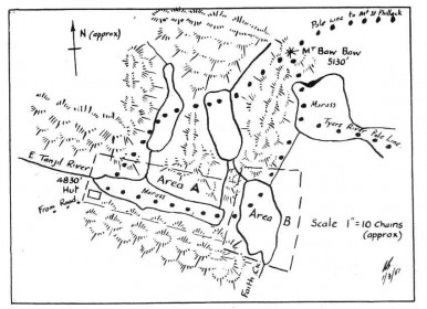
During the early 1940's, members of the Erica Division of the SCV began investigating the skiing potential of the Baw Baw Plateau, much of which is around 1500m altitude. The Mt. Erica Division of the SCV in 1945 built a 9m by 5m hut on the headwaters of the East Tanjil River (Area A, Photo No.14) about 800m from the Baw Baw summit. The hut was equipped with 18 bunks just prior to the start of the 1946 ski season. The Mt. Erica Division ran regular fortnightly bus trips from Yallourn to Baw Baw in the 1946 ski season and on some days had as many as 150 people on the field (SYB 1947).
Following a visit by the State Development Committee to Mt. Baw Baw and all other Victorian snowfields in 1950, a report on the Alpine Regions of Victoria was prepared and presented to the Victorian Parliament in July 1950. The committee recommended the development of Mt. Baw Baw as a ski resort. Following a September 1950 visit by two Ministers in the Victorian Cabinet (T.W. Mitchell and W.O. Fulton), it was considered that the ski village should include both areas A and B on the map below (Photo No.14)
Further development at Baw Baw was restricted by the lack of an all-weather road onto the plateau at the proposed village site, for a further twelve years. Such a road was only completed in 1962. The Mt. Baw Baw Ski Club was still the only club to have a lodge in the Baw Baw Village in 1963.
During the 1940's and 1950's, Mt. Buffalo was the Cradle of organized skiing in Victoria with the declared objective of "learn to ski in a week". The Mount Buffalo Chalet (operated by the Victorian Railways and configured to hold about 180) had sufficient winter accommodation to introduce between 900 and 1,000 beginners each year to skiing. At that time the ski school was based at Dingo Dell, a sheltered slope that is flattish at top and bottom and extremely wide. On one side of the run was an endless-rope ski tow that did not require artificial grips, such as a "nut-cracker" and was so simple that it could be ridden by second-day skiers. Huts near the ski run served hot lunches daily and provided shelter should the weather deteriorate. Mount Buffalo's status as the prime Victorian ski school, slowly slipped away when ski schools were established at Buller, Hotham and Falls Creek by the 1960's.
The Tallangatta Ski Club (TSC), initially comprising 117 members from the extensive district surrounding Tallangatta, was formed in December 1947 and affiliated with the North-Eastern District Ski Association (NEDSA). The most accessible high country close to Tallangatta is Mt. Wills (altitude 1755m), 102km south of Tallangatta. The Razorback Spur provides the easiest access to the plateau and to the summit of Mt Wills. In 1948 the TSC constructed its ski lodge at 1500m altitude on the Razorback Spur about 1.5km along a vehicular track from where the Omeo Highway crosses the Razorback Spur at 1340m altitude.
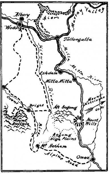
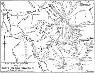
From this point there is an easier and more sheltered approach along the Wills Spur, shown on the Mt. Bogong map (rising about 250m in about 10km length) to the Cleve Cole Hut on Mt. Bogong, than is afforded by the Staircase Spur. The club lodge was constructed largely from timber growing on the lodge site. The lodge has a sawn and split-timber frame, walled with split slabs standing vertically, on "round-timber foundations", measuring overall 9m by 4.5m, divided into three rooms. The lodge was at the "lock-up stage" by 3/7/1948. It operated its own rope tow in the 1954 ski season.
(The localities named in this Chapter, are shown on the Mt. Bogong Map)
To understand why Mount Bogong (1984 m), Victoria's highest mountain, has not been developed as a ski resort, it is necessary to look back to the 1930's and 1940's, the period over which it became clear that Mount Bogong was frequently impacted by severe blizzards that threatened the survival of any skier or walker who happened to be on the exposed upper mountain slopes when this wild weather arrived.
At 8.00am on Saturday August 8, 1936, three experienced Victorian ski tourers - Cleve Cole, Howard Michell and Mick Hull - left their camp near the banks of the Big River to climb the 1060 vertical metres to the western end of the summit ridge of Mt. Bogong. The weather deteriorated markedly as they climbed, encountering very dense fog, driving sago-snow, gale-force winds from the North-West and icy snow conditions on the plateau-like summit ridge. Navigation was almost impossible with the very poor visibility (less than two metres) and, as they had not made any tracks in the icy surface, it was not possible to return along their tracks back down to the more sheltered valley of the Big River. They tried to get off the mountain by any spur they could find, but each attempt ended on the edge of sheer cliffs.
They found a gully which provided some slight shelter on a 25 degree slope and dug a snow cave in which they spent 3 days and 4 nights while the blizzard continued to rage outside. With food running low, further efforts were made to find their way off the mountain via the Summit Cairn and the Staircase Spur to the Bivouac Hut. The wind was howling in fierce gusts and with the visibility no more than 18m and often less, they stumbled across the Summit Cairn, but could not find the Staircase Spur. After a series of descents that always ended in steep rocky cliffs, they accidently descended the South side, instead of the intended North side, ending in the valley of the Big River. They had probably been blown completely off course by the howling wind. Cleve Cole was in poor condition and Mick Hull volunteered to stay with Cleve whilst Howard walked down the river to seek help.
Howard Michell reached a farmhouse in Glen Valley on Monday morning 17 August and immediately triggered a search for his two companions, whom he had left two days earlier to summon help. Unfortunately, four hours after his rescuers had carried him into the village of Glen Valley, Cleve Cole died from the adverse effects of his exposure to the extreme blizzard conditions on Mount Bogong and its aftermath in the very rugged terrain of the Big River.
The Victorian skiing community was shocked not only by death of Cleve Cole and the frostbite suffered by his two companions, but also by the severity of the conditions they had experienced. Snow pole lines were then constructed on Mount Bogong to guide skiers to safety, particularly in poor visibility, and refuge huts were built, including a substantial hut dedicated to the memory of Cleve Cole.
Location of Mount Wills Photo15[SYB, 1949]
Summit Hut at Top of Staircase Spur Photo16 [Mick Hull]
Mount Bogong, Staircase Spur and the Big River Photo17a [Heritage Mt. Bogong Map]
Memorial Cairn on Staircase Spur Photo17b [P.G. Haddow, 1950]
However, when a further tragedy occurred on Mt. Bogong in 1943, the Victorian ski community started to seriously question whether that mountain should be developed for general skiing or remain a wilderness area. At 12.30pm on Monday August 2 1943, a party of three skiers (Georgine Gadsden, John McRae and Edward Welch) departed Bivouac Hut on the Staircase Spur (4,900 ft./ 1493 m ) bound for Summit Hut (6,410 ft./ 1954 m) where they planned to spend the night, with the Cleve Cole Memorial Hut being their ultimate destination. Between them they carried sufficient food to last about five days and their packs weighed from about 15kg (Gadsden) to about 22kg (Welch). Snow was falling, a strong north-westerly wind was blowing and visibility was about ten metres, but the party did not consider conditions unduly severe. Ian Lenne and four other skiers chose to remain at Bivouac Hut and wait for some improvement in the weather.
After making an attempt to follow the first party the next morning, Ian Lenne's group returned to Bivouac Hut in very poor weather conditions and remained there for two more nights whilst a blizzard raged on the mountain. "There is often a rapid increase in the severity of conditions on the Staircase Spur once the tree line is left behind. Such is the architecture of the mountain at this point that, having left the comparative protection of the trees and sidled around the twin knobs of Castor and Pollux, one suddenly runs into a numbing blast of wind-driven snow at Gorge Gap". (The view up the Staircase Spur from Gorge Gap is shown in Photo No. 16.) "A few apprehensive steps further and one is locked into the final climb onto the Summit Ridge. The first section of this is particularly steep. In order to proceed, it is often necessary to resort to the particularly exhausting procedure of kicking steps. For each gain in height there is frequently an alarming increase in the severity of the conditions. One seems to be climbing into a nightmare. The wind at times blows downhill, sometimes bringing the climber to a halt and on occasions blowing him backwards. Progress slows to a few steps at a time." (Geoff Schirmer writing in WILD, Oct-Dec 1981).
On Thursday August 5 it was still snowing but with a moderating wind. Lenne's group headed once more for the Summit Hut. Following the snow pole line on very icy slopes, about five hours after leaving the Bivouac Hut, they came across the three frozen bodies of the members of the first party lying in the snow at the last visible snow pole, about 80 metres from the almost completely buried Summit Hut. Had the first party also taken five hours in the blizzard conditions to reach this point, they would have arrived at the last visible snow pole as daylight faded at about 5.30pm.
Edward Welch was lying face downward with his pack still on his back. About two metres further up the slope was John McRae's body lying against his pack which was still strapped to his back. Georgine Gadsden's body was a further two metres up the slope, lying on her back on her pack which evidently she had removed so she could better assist her companions.
A contemporary account of the tragedy (SCHUSS September-October 1943) suggests that Welch may have been stationed beside the last exposed snow pole whilst Georgine Gadsden and John McRae had been looking for the next snow pole and/or the Summit Hut. Unfortunately it seems possible that Welch collapsed whilst standing at the last exposed snow pole, because he still had his pack on his back and had fallen face-first into the snow. Welch was the only member of the party to have previously visited the Summit Hut in winter. McRae, possibly also on the point of collapse, might have sat down nearby. The posture in which he was found was judged to be "consistent with his having endeavoured to rise, but, being unable to do so, had then been given the brandy flask. That it may have been dark is possibly suggested by the finding of a torch in the snow near the bodies. . . . In such circumstances, Miss Gadsden would be well-nigh exhausted, bitterly cold, and alone in a strange place under terrifying conditions. She would undoubtedly be loath to leave her companions, but even should she have realized that the only chance of saving her own life lay in a retreat down the spur to the shelter of Mountain Creek, then she would be faced with having to make a descent into the full force of the north-westerly blizzard on an icy surface, with no one to assist her to find her way from one snowpole to the next. It seems that Miss Gadsden chose to remain with her companions . . . . ."
This sad experience underlined for once and for all, that although Mt. Bogong is Victoria's highest mountain and is capable of providing magnificent ski runs in good weather, it is utterly exposed in bad weather and lacks sheltered access. It is a mountain for ski mountaineers and experienced skiers; it is definitely not for family groups with small children who are learning to ski.
The Victorian Railways Department, which operated the Chalet at Mount Buffalo for over 50 years, constructed Australia's first ski tow on the Cresta Run, Mount Buffalo, in August 1937 (Photo No.19). The tow was located in a clearing beside the actual Cresta Run, so as to keep the downhill skier traffic separate from those riding the tow back to the top. The rope moved at about 8 km/hr and initially no mechanical grips were used; the rope was simply gripped with both hands. There were no intermediate poles with pulleys, so as to prevent the rope from dragging in the snow whenever there were not several skiers spaced along it. This is an example of Australian inventiveness – a ski tow was needed and the engineers simply built it from whatever materials were available.
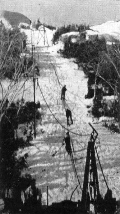
It was not long before the intense NSW – Victoria rivalry in the snowfields resulted in a reply from the NSW snowfields, most of which in the 1930's were operated by the NSW Government. At the same time as the new Charlotte's Pass Chalet was being built to replace the first chalet that burned down during the ski season on 8 August 1938, the first NSW ski tow (Photo No. 20) was constructed on the nearby slope. Like the Mount Buffalo tow, it was built from easily available materials by the engineering staff, in this case the NSW Government Railways. Built as a "J Bar" lift, it first operated in the 1939 Winter. The "Report for 1939" of the Ski Council of NSW stated "The ski hoist which was built close to the new Chalet has been a great acquisition. The effect of the increased amount of downhill running which practically everybody has been able to obtain, is a tremendous improvement in the general standard of ski-ing in the State." Stoppages did occur due to mechanical problems, adverse weather conditions and "carelessness on the part of skiers themselves". . . . "but on the whole such inconveniences were slight, and there can be few skiers, if any, who are not heartily thankful to the Department for providing the ski hoist." Ski clubs that stayed at the Chalet and used the lift in 1939 included the Kosciusko Alpine Club, Kosciusko Snow Revellers Club, Ski Club of Australia, Sydney Ski Club, Torchbearer Ski Club and the Cooma Ski Club (whose members were grateful for the snow reports regularly transmitted by radio Station 2XL Cooma).
Historical Note: Antarctic Explorer Captain Frank Hurley, the famous Australian photographer who first came to prominence with his film of the 1914 – 1916 Shackleton Expedition (Photo No. 21), took Photo No. 20.

